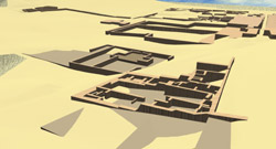
![]() The 2002 field
season marked the beginning of an important phase of the Ychsma Project :
the making of a new complete map of the site, as well as a digital
animated model of the whole monumental sector. The season took place
in February and March, 2002. The most advanced technology was used
( a total station, GPS and CAD resources). We were fortunate to acquire
the expert assistance of Daniel Parent, a French Topographer from the
Association pour les Fouilles Archéologiques Nationales (France).
Pyramid Complexes n°3 and n°11 were surveyed and mapped as
test examples. We also surveyed the general topography of the site
and the limits of the main structures. This led to the discovery of
a new pyramid hitherto unknown : Pyramid with ramp n°15. Maps and
models have been processed and represent the first stages of a project
which is scheduled to be completed in 2007.
The 2002 field
season marked the beginning of an important phase of the Ychsma Project :
the making of a new complete map of the site, as well as a digital
animated model of the whole monumental sector. The season took place
in February and March, 2002. The most advanced technology was used
( a total station, GPS and CAD resources). We were fortunate to acquire
the expert assistance of Daniel Parent, a French Topographer from the
Association pour les Fouilles Archéologiques Nationales (France).
Pyramid Complexes n°3 and n°11 were surveyed and mapped as
test examples. We also surveyed the general topography of the site
and the limits of the main structures. This led to the discovery of
a new pyramid hitherto unknown : Pyramid with ramp n°15. Maps and
models have been processed and represent the first stages of a project
which is scheduled to be completed in 2007.
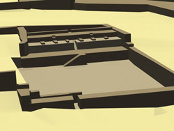
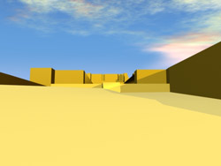 Pyramid
3-A (Directors : P. Eeckhout & C. Farfán ; Survey :
Daniel Parent ; CAD processing : V. Thieren) Pyramid
3-A (Directors : P. Eeckhout & C. Farfán ; Survey :
Daniel Parent ; CAD processing : V. Thieren) |
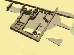
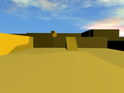 Pyramid
3-B(Directors : P. Eeckhout & C. Farfán ; Survey :
Daniel Parent ; CAD processing : V. Thieren) Pyramid
3-B(Directors : P. Eeckhout & C. Farfán ; Survey :
Daniel Parent ; CAD processing : V. Thieren) |
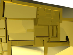 Platform
of Pyramid 3-B (Directors : P. Eeckhout & C. Farfán ;
Survey : Daniel Parent ; CAD processing : V. Thieren) Platform
of Pyramid 3-B (Directors : P. Eeckhout & C. Farfán ;
Survey : Daniel Parent ; CAD processing : V. Thieren) |
 Temple
of the Monkey (Directors : P. Eeckhout & C. Farfán ;
Survey : Daniel Parent ; CAD processing : V. Thieren) Temple
of the Monkey (Directors : P. Eeckhout & C. Farfán ;
Survey : Daniel Parent ; CAD processing : V. Thieren) |
 Pyramid
11 form the North (Directors : P. Eeckhout & C. Farfán ;
Survey : Daniel Parent ; CAD processing : V. Thieren) Pyramid
11 form the North (Directors : P. Eeckhout & C. Farfán ;
Survey : Daniel Parent ; CAD processing : V. Thieren) |
 Pyramid
11 and site view 2002 (Directors : P. Eeckhout & C. Farfán ;
Survey : Daniel Parent ; CAD processing : V. Thieren) Pyramid
11 and site view 2002 (Directors : P. Eeckhout & C. Farfán ;
Survey : Daniel Parent ; CAD processing : V. Thieren) |